Scheduled_Task_Allocation_Radar(STAR)_v2
Overview (概要)
このビークルデータは、レーダーデータと搭載された物理センサー情報を統合する、高度な目標追跡システムを提供します。カルマンフィルタを利用して複数目標の安定したトラックを維持し,
システムに統合された追跡情報(Unified_Track_Data_Format_v2)を提供します。
This script provides ένα advanced target tracking system that fuses radar data with onboard physics sensors. It utilizes a Kalman Filter to maintain stable tracks on multiple targets, predict their future positions, and provide a fused target solution for weapon systems.
| | input format |
|------------|-------------------------|------------------------------
| | input radar information |
| pin number | input bool | input number
| 1 | radar detect | radar distance[m]
| 2 | radar detect | radar azimuth[rot]
| 3 | radar detect | radar elevation[rot]
| 4 | radar detect | radar timesince[ticks]
| 5 | radar detect | radar distance[m]
| 6 | radar detect | radar azimuth[rot]
| 7 | radar detect | radar elevation[rot]
| 8 | radar detect | radar_rotation[rot]
| 9 | not used | radar distance[m]
| 10 | not used | radar azimuth[rot]
| 11 | not used | radar elevation[rot]
| 12 | not used | physics sensor pos x [m]
| 13 | not used | radar distance[m]
| 14 | not used | radar azimuth[rot]
| 15 | not used | radar elevation[rot]
| 16 | not used | physics sensor pos y [m]
| 17 | not used | radar distance[m]
| 18 | not used | radar azimuth[rot]
| 19 | not used | radar elevation[rot]
| 20 | not used | physics sensor pos z [m]
| 21 | not used | radar distance[m]
| 22 | not used | radar azimuth[rot]
| 23 | not used | radar elevation[rot]
| 24 | not used | physics sensor euler x [rad]
| 25 | not used | radar distance[m]
| 26 | not used | radar azimuth[rot]
| 27 | not used | radar elevation[rot]
| 28 | not used | physics sensor euler y [rad]
| 29 | not used | radar distance[m]
| 30 | not used | radar azimuth[rot]
| 31 | not used | radar elevation[rot]
| 32 | not used | physics sensor euler z [rad]
| output format | |
|---------------|------------------------|
| output always | |
| output bool | output number |
| is data 1 | position_x [m] |
| is data 2 | position_y [m] |
| is data 3 | position_z [m] |
| remove flag 1 | velocity_x [m/ticks] |
| remove flag 2 | velocity_y [m/ticks] |
| remove flag 3 | velocity_z [m/ticks] |
| not used | covariance_pos_x [m^2] |
| not used | covariance_pos_y [m^2] |
| not used | covariance_pos_z [m^2] |
| not used | Tracking ID |
| not used | position_x [m] |
| not used | position_y [m] |
| not used | position_z [m] |
| not used | velocity_x [m/ticks] |
| not used | velocity_y [m/ticks] |
| not used | velocity_z [m/ticks] |
| not used | covariance_pos_x [m^2] |
| not used | covariance_pos_y [m^2] |
| not used | covariance_pos_z [m^2] |
| not used | Tracking ID |
| not used | radar control pivot |
| not used | |
情報の出力は、新しいデータを観測したときだけ行われます。
Outputs are updated when a track's state is refreshed.
## parameters
| Tracking ID = NodeID*ID_POOL_SIZE + local id | |
|----------------------------------------------|-----------------------------------------------|
| property | |
| name | explanation |
| Node_ID | sensor id |
| ID_Pool_Size | id pool size |
| Track_TTL | track ttl if over it remove track |
| FOV_X | radar fov azimuth [rot] |
| FOV_Y | radar fov elevation [rot] |
| Radar_Pitch_Angle | radar line of sight pitch |
| Pivot_Gear_Ratio | pivot gear ratio selector |
| Threat_Engagement_Threshold | since_last_detection/TTL>this ,then queue task |
プロパティ名 (Name) 説明 (Explanation)
Node_ID このセンサーユニットのユニークID。特に複数のレーダーを連携させる場合に使用します。
ID_Pool_Size このスクリプトが内部で管理できるトラックの最大数。
Track_TTL Time-To-Live(生存時間)。このtick数だけ目標が更新されない場合、そのトラックは削除されます。
FOV_X / FOV_Y レーダーの探知範囲である水平/垂直の視野角 [rotations]
Radar_Pitch_Angle レーダーの固定ピッチ角 [rotations]
Pivot_Gear_Ratio 旋回軸のギア比。ハードウェアに合わせて設定してください。
Threat_Engagement_Threshold 脅威交戦閾値。(最終探知からの時間 / TRACK_TTL)がこの値を超えると、レーダーが再探査を試みます。
(追跡IDについて) Tracking ID = NodeID * ID_POOL_SIZE + local_id の形式で生成されます。
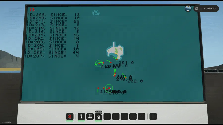
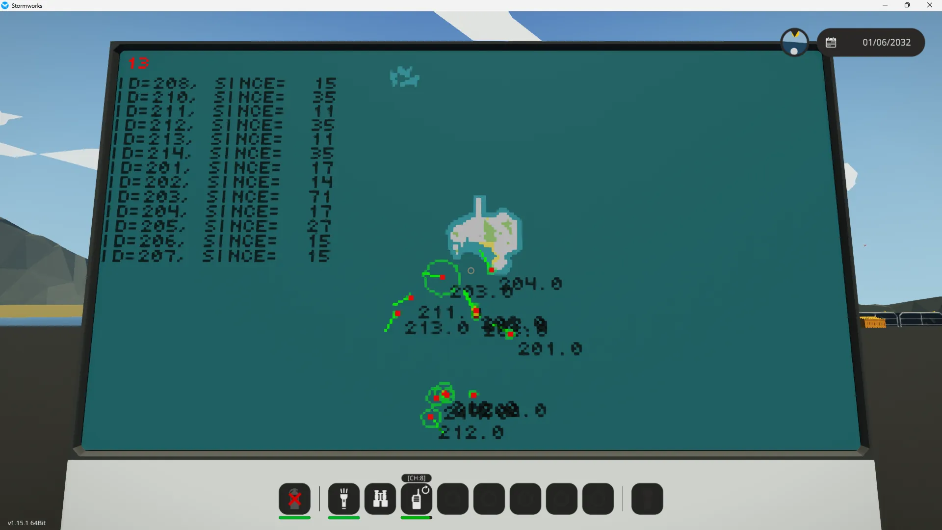
このアイテムには、本スクリプトから出力される追跡データを受け取り、マップ上に目標をアイコンで描画する'Unified_Track_Data_Format_Visualizer_v2'が同梱されています。デバッグや戦術マップの構築にご活用ください。
### 広告
このレーダと同じ出力Unified_Track_Data_Formatの情報を受け取りを再帰的に統合するシステムも公開しているのでぜひ。上記のフォーマットさえ同じならばあなたの、オリジナルの作品も統合できます。
### **謝辞 (Acknowledgements)**
この作品を完成させるにあたり、多くの知見やデータを提供してくださった先人たちに、心からの感謝を捧げます。
全てのStormworkerに感謝♡。